Published page
Hurricane season


The hurricane season refers to the specific period within a year when tropical cyclones, including hurricanes, typhoons, and tropical storms, are most likely to form over ocea…
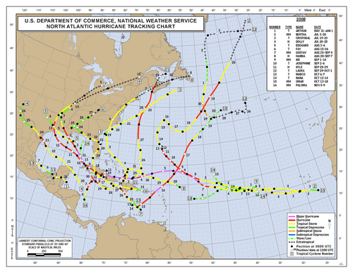
Hurricane season
The hurricane season refers to the specific period within a year when tropical cyclones, including hurricanes, typhoons, and tropical storms, are most likely to form over ocea…
National Hurricane Center · Public domain · 2008 Atlantic hurricane season map.png
The hurricane season refers to the specific period within a year when tropical cyclones, including hurricanes, typhoons, and tropical storms, are most likely to form over oceanic basins due to favorable atmospheric and oceanic conditions.
While tropical cyclones can technically form at any point during the calendar year if conditions permit, the vast majority of activity is concentrated within these climatologically defined windows.
1. Overview
Tropical cyclones require a specific set of environmental criteria to generate and sustain themselves. The primary driver of a hurricane season is the sea surface temperature, which generally needs to reach or exceed $26.5^\circ\text{C}$ ($79.7^\circ\text{F}$) through a relatively deep layer of water.[1]https://www.nhc.noaa.gov/climo — This specific temperature threshold serves as the thermal critical point where ocean evaporation releases enough latent heat energy to sustain tropical cyclogenesis. Additionally, low vertical wind shear, high atmospheric moisture, and pre-existing weather disturbances are essential prerequisites. Because the sun's angle shifts throughout the year, ocean waters absorb heat during the summer months and reach their peak temperatures in late summer and early autumn. Consequently, hurricane seasons typically peak during these months in their respective hemispheres.
2. Regional Seasons
The timing of the hurricane season varies significantly depending on the oceanic basin, largely dictated by geographic location and seasonal climate patterns.
The Atlantic hurricane season officially runs from June 1 to November 30. This basin includes the North Atlantic Ocean, the Caribbean Sea, and the Gulf of Mexico. Climatologically, the peak of activity occurs in mid-September, specifically around September 10, when ocean temperatures are at their warmest and atmospheric conditions are most conducive to storm development.
The Eastern Pacific basin covers the Pacific Ocean east of $140^\circ\text{W}$. Its official season begins slightly earlier than the Atlantic, running from May 15 to November 30. This earlier start is attributed to the quicker warming of waters off the western coast of Central America and Mexico.
In the Western Pacific, tropical cyclones are referred to as typhoons. Unlike most other basins, the Western Pacific experiences typhoon activity year-round due to the vast expanses of warm water in the tropical Pacific.[2]Because the Western Pacific Warm Pool retains deep warm water year-round, tropical cyclones can form even in January, making it the only ocean basin on Earth with no true off-season. However, the most active period occurs between July and November, with a pronounced peak in late August and September.
The Northern Indian Ocean exhibits a unique bimodal season. Tropical cyclones in this region typically form between April and June, and again between October and November, avoiding the height of the summer monsoon season due to high wind shear. In the Southern Hemisphere—which includes the Australian region, the South Pacific, and the South-Indian Ocean—the season runs from November 1 to April 30, reflecting the inverted seasons of the southern climate.
3. Formation Mechanisms and Climate Drivers
The annual recurrence of hurricane seasons is driven by global thermodynamic processes. During the operational period of a season, the Intertropical Convergence Zone shifts, providing the necessary low-level atmospheric convergence.
Broader climate phenomena also exert a powerful influence on the intensity and frequency of any given season. The El Niño-Southern Oscillation is a major driver of interannual variability. During El Niño events, vertical wind shear increases over the Atlantic Basin, suppressing storm formation, while simultaneously enhancing activity in the Pacific. Conversely, La Niña conditions tend to foster highly active Atlantic hurricane seasons while reducing activity in the Eastern Pacific.
4. Observation and Forecasting
Modern meteorological agencies continuously monitor oceanic basins during their active seasons using meteorological satellites, ocean buoys, and reconnaissance aircraft commonly known as hurricane hunters.[3]The human crews on aircraft such as the U.S. Air Force Reserve 53rd Weather Reconnaissance Squadron intentionally fly directly through the eyewall of severe hurricanes to drop sondes and measure centr Tropical cyclone warnings, seasonal outlooks, and path predictions are issued by designated Regional Specialized Meteorological Centres established by the World Meteorological Organization. These agencies assess potential threats and alert coastal populations to minimize loss of life and infrastructure damage.
5. Trivia
5.1 The Post-Equinoctial Climax
While public perception often aligns the peak of the North Atlantic hurricane season with the height of midsummer heat in July or August, the statistical peak occurs on September 10. This temporal lag is driven by the ocean's thermal inertia, as water possesses a significantly higher specific heat capacity than land, requiring months of sustained summer solar radiation to reach the threshold sea surface temperatures ($26.5^\circ\text{C}$ or $79.7^\circ\text{F}$) necessary to fuel tropical cyclogenesis. Consequently, over $80\%$ of major Atlantic hurricanes (Category 3 and above) develop between late August and October, coinciding with the seasonal minimum of vertical wind shear across the Caribbean Basin.
5.2 The Cape Verde-Type Cyclogenesis
The most destructive and long-lived trans-Atlantic hurricanes originate thousands of miles away from North America, off the western coast of Africa. During the height of the season, African Easterly Waves—disruptions in the lower atmospheric jet stream caused by thermal contrasts between the Saharan desert and the moist Gulf of Guinea—propagate westward into the Atlantic Ocean. Near the Cape Verde archipelago, these low-pressure disturbances encounter warm water and minimal atmospheric stability, organizing into powerful tropical depressions that cross the entire ocean basin over the span of two weeks.
5.3 The Quadrant-Based Asymmetry
A hurricane’s destructive force is not uniformly distributed throughout its circular structure due to the vector addition of the storm's translational velocity and its rotational wind field. In the Northern Hemisphere, where cyclones rotate counterclockwise due to the Coriolis effect, the right-front quadrant (relative to the direction of motion) experiences the highest compound wind speeds, maximum storm surge, and greatest frequency of embedded tornadoes. Conversely, the left-rear quadrant exhibits reduced net wind speeds as the forward motion of the storm partially cancels out the counterclockwise winds.
5.4 The Greek Alphabet Precedent
Prior to the 2021 season, if the World Meteorological Organization (WMO) exhausted its standard annual 21-name alphabetical list (which omits Q, U, X, Y, and Z), additional storms were designated using the Greek alphabet ($\alpha, \beta, \gamma$, etc.).[4]The standard Atlantic name list limits itself to 21 names because finding sufficient recognizable, distinct names starting with Q, U, X, Y, or Z proved impractical. This auxiliary system was utilized only twice: during the record-breaking 2005 season and the 2020 season. However, the WMO officially retired the Greek alphabet in 2021, citing that the usage of minor Greek letters created public confusion and obscured the significance of devastating storms (such as Hurricanes Eta and Iota in 2020), which could not be properly "retired" from a standard static alphabet. A supplemental list of conventional names is now utilized instead.
5.5 The Fujiwhara Phenomenon
During periods of heightened seasonal activity, multiple tropical cyclones may form in close geographic proximity. When two systems approach within approximately $1,400\text{ km}$ ($870\text{ miles}$) of each other, they begin to orbit a shared barometric center of mass rather than following independent paths. Known as the Fujiwhara Effect, this interaction can lead to complex trajectories where the smaller cyclone is absorbed by the larger one, or both systems orbit each other before being ejected on entirely new tracks, severely complicating predictive computer modeling.[5]Japanese meteorologist Sakuhei Fujiwhara first identified this orbital phenomenon in 1921 while observing the vortex dynamics of water currents.
5.6 The Warm-Core Anomaly
Unlike mid-latitude extratropical cyclones, which are driven by horizontal temperature gradients (fronts) and possess cold cores, hurricanes operate as thermodynamic heat engines driven by the release of latent heat. As moist air ascends around the eyewall, water vapor condenses, releasing vast amounts of thermal energy directly into the upper troposphere. This process creates a "warm core" where temperatures at high altitudes inside the eye can be up to $10^\circ\text{C}$ ($18^\circ\text{F}$) warmer than the surrounding atmosphere, effectively lowering the surface pressure and accelerating the storm's central intake.
5.7 The Multidecadal Signal
Seasonal hurricane activity in the Atlantic Basin is not constant year-over-year but fluctuates according to the Atlantic Multidecadal Oscillation (AMO). The AMO is a 20- to 40-year natural cycle in sea surface temperature anomaly patterns. During a "warm phase" of the AMO, the Atlantic experiences significantly elevated seasonal hurricane frequency and intensity, whereas a "cold phase" suppresses cyclone activity regardless of short-term seasonal forecasts, demonstrating that localized seasonal severity is heavily anchored to macro-scale oceanic cycles.
Child documents of "Hurricane season"
None yet.