Published page
Time zone


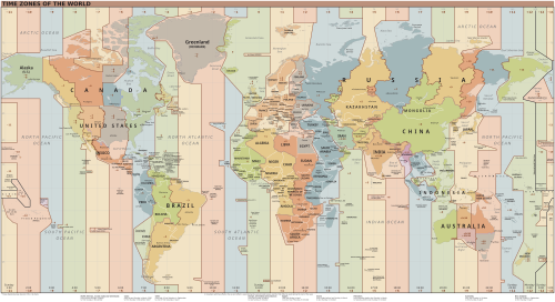
A time zone refers to a specific geographic region on Earth that observes a uniform standard time for legal, commercial, and social purposes.
Time zone
A time zone refers to a specific geographic region on Earth that observes a uniform standard time for legal, commercial, and social purposes.
Heitordp · Public domain · World Time Zones Map.svg
A time zone refers to a specific geographic region on Earth that observes a uniform standard time for legal, commercial, and social purposes.
Historical timekeeping relied on local solar time, where noon was defined as the moment the sun reached its highest point in the sky. However, this system resulted in virtually every town maintaining a slightly different clock time, causing severe confusion as international travel and modern telecommunications expanded during the late nineteenth century. The establishment of time zones solved this issue by grouping adjacent territories together under a shared, standardized clock time.
1. Overview and Principles
The fundamental framework of global time zones is based on the Earth's rotation. Because the planet completes a full 360-degree rotation approximately once every 24 hours, the surface is theoretically divided into 24 principal meridional bands, each spanning 15 degrees of longitude. Each band corresponds to an offset of one hour relative to a baseline standard.
The modern global baseline is Coordinated Universal Time (UTC), which superseded Greenwich Mean Time (GMT) for precise scientific timekeeping. Time zones are designated by their offset relative to UTC, expressed in hours and minutes such as UTC+00:00, UTC+09:00, or UTC-05:00. Regions located east of the Prime Meridian observe times ahead of UTC, while regions to the west observe times behind UTC.
2. Political and Geographic Boundaries
Although the ideal theoretical model consists of uniform 15-degree longitudinal strips, actual geographic time zone boundaries rarely follow straight lines. National governments possess full sovereignty to determine the standard time observed within their jurisdiction. Consequently, time zone boundaries are distorted to align with international borders, political subdivisions, geographical landmarks, and major economic trade routes.
Political considerations can lead to unique regional time configurations:
- Single National Time Zones: Some expansive countries choose to maintain a single national time zone despite spanning multiple theoretical 15-degree bands. The most notable example is the People's Republic of China, which operates entirely on Beijing Time (UTC+08:00) across its vast geographical expanse.[1]https://www.gov.cn — The country previously maintained five separate time zones established during the Republican era, but unified them into a single standard offset following the establishment of the central government.
- Non-Hour Offsets: Certain territories utilize time zones that are offset from UTC by half-hour or quarter-hour increments rather than full hours. Examples include India (UTC+05:30), Iran (UTC+03:30), Nepal (UTC+05:45), and parts of Central Australia (UTC+09:30).
- Multi-Zone Nations: Countries with broad transcontinental territories, such as Russia, the United States, and Canada, divide their landmass into several administrative time zones to prevent extreme discrepancies between standard local clock time and actual daylight hours.
3. Daylight Saving Time
Daylight Saving Time (DST), often referred to as Summer Time in various regions, is a system where local clocks are advanced by one hour during warmer months to extend evening daylight and potentially conserve energy. The implementation and observance of Daylight Saving Time vary significantly across the globe.
Regions near the equator typically do not observe Daylight Saving Time because seasonal variations in daylight hours are minimal. High-latitude regions in Europe and North America frequently adjust their clocks seasonally, although the practice has been a subject of ongoing debate among policymakers, health researchers, and economic analysts. Many countries that previously implemented daylight adjustments have permanently abolished the practice in favor of year-round standard or daylight time.
4. International Date Line
The International Date Line (IDL) serves as the official boundary where calendar days transition. Located roughly along the 180th meridian in the Pacific Ocean, crossing the line from west to east results in subtracting one calendar day, while crossing from east to west results in adding one calendar day.
Similar to standard time zone boundaries, the International Date Line does not follow a straight longitudinal line. It bends around various Pacific island nations and territories, such as Kiribati, to ensure that entire national archipelagos share the same calendar date and business days as their primary economic partners.
5. Trivia
5.1 Temporal Fragmentation of the People's Republic of China
Despite spanning approximately 5,000 kilometers from east to west—a longitudinal breadth naturally encompassing five distinct geographical time zones (UTC+5 to UTC+9)—the People's Republic of China officially enforces a single unified standard time: Beijing Time (UTC+8). Established by the Chinese Communist Party following the founding of the PRC in 1949, this hyper-centralized temporal policy was designed as a symbolic tool for national unity.
Consequently, extreme solar anomalies occur in the westernmost regions, such as Xinjiang. In cities like Kashgar, the sun does not reach its zenith until around 3:00 PM, and winter sunsets occur past 9:00 PM. To cope with this official distortion, the native Uyghur population informally utilizes "Xinjiang Time" (UTC+6, two hours behind Beijing), leading to a dual-temporal reality where standard time functions as a socio-political identifier alongside regional ethnic lines.[2]This informal distinction occasionally causes practical confusion, as local store opening hours and public transportation schedules vary depending on whether the operator observes official standard ti
5.2 Fractional Hour Anomalies of the Indian Subcontinent and Australasia
While the international Coordinated Universal Time (UTC) framework predominantly operates on one-hour increments, several sovereign nations and territory administrations maintain fractional standard offsets calculated in 30-minute or 15-minute intervals.
Nepal utilizes UTC+5:45, an offset based on the meridian passing through Phulchoki hill near Kathmandu, intentionally positioned 15 minutes ahead of India's Standard Time (UTC+5:30) to assert geopolitical independence from its larger neighbor.[3]The country originally observed a 5-hour and 40-minute offset from GMT based on an earlier reference meridian before shifting to the modern 45-minute alignment in 1986. Similarly, the Chatham Islands of New Zealand enforce UTC+12:45. In Australia, the central region (including South Australia and the Northern Territory) operates on UTC+9:30, while an unincorporated micro-region known as Eucla along the Eyre Highway enforces an unofficial, localized offset of UTC+8:45.
5.3 The Diomede Islands and the Temporal Chasm of the Bering Strait
Located within the Bering Strait, Big Diomede (under Russian jurisdiction) and Little Diomede (under United States jurisdiction) are separated by a physical distance of merely 3.8 kilometers. However, the International Date Line (IDL) bisects the water between these two islands.
Because Big Diomede operates on Kamchatka Time (UTC+12) and Little Diomede operates on Alaska Standard Time (UTC-9), the temporal disparity between the islands stands at 21 hours during winter, expanding to 20 hours during Daylight Saving Time. Consequently, residents of Little Diomede can physically observe Big Diomede—visually accessible across the narrow strait—existing chronologically within the subsequent calendar day, earning them the moniker "Yesterday Island" and "Tomorrow Island."[4]Due to the extreme proximity across the maritime border, observers standing on the eastern island can look across the water to see land where the calendar date is already ahead.
5.4 The Line Islands and the Elimination of May 30, 1995
Prior to 1995, the territorial expanse of the Republic of Kiribati was bisected by the International Date Line, causing the eastern Line Islands and Phoenix Islands to lag up to 23 hours behind the western Gilbert Islands. This created a situation where the nation experienced only four overlapping business days per week.
Effective January 1, 1995, the Kiribati government unilaterally altered the trajectory of the International Date Line by shifting the eastern territories from UTC-11 and UTC-10 to UTC+13 and UTC+14. To achieve this adjustment without altering the day of the week sequence, the calendar skipped the date of December 31, 1994, proceeding directly from December 30 to January 1.[5]This rare calendar adjustment effectively caused the entire territory to skip a day entirely, making the missed date non-existent on local calendars. As a result of this realignment, Caroline Atoll (renamed Millennium Island) became the easternmost point of standard time on Earth, securing its status as the first inhabited landmass to enter the year 2000.
5.5 Temporal Density at the Terrestrial Poles
At the Geographic North and South Poles, all longitudinal meridians converge to a singular point of spatial singularity, rendering traditional geographic time zones theoretically obsolete. Polar expedition stations and research bases operating in Antarctica generally adopt the time zone of their primary supply hub or home nation rather than relying on local solar position—which is practically meaningless given the six-month polar days and polar nights.
For example, Amundsen–Scott South Pole Station utilizes New Zealand Time (UTC+12 / UTC+13 DST) because its logistics chain operates out of Christchurch. Conversely, McMurdo Station, Palmer Station (UTC-3), and Station Vostok (UTC+6) maintain disparate temporal frameworks despite their relative polar proximity, creating a complex patchwork of administrative time zones across the Antarctic continent.
5.6 Historical Residuals of Railway Standard Time
Prior to the late 19th century, standard time zones did not exist; virtually every municipality maintained its own local solar time based on the high sun position of its localized meridian. The introduction of high-speed intercity rail transit during the Industrial Revolution created massive logistical chaos, as train schedules had to account for hundreds of disparate local times across single routes.
To resolve this operational inefficiency, British railway companies began adopting a uniform time across the rail network in 1847, utilizing Greenwich Mean Time (GMT). This standardized framework, initially known as "Railway Time," laid the infrastructural precedent for the International Meridian Conference of 1884 in Washington, D.C., where GMT was officially selected as the global prime meridian standard, establishing the foundational grid for modern international timekeeping.
Child documents of "Time zone"
None yet.