Published page
Tornado season


Tornado season refers to the annual period during which atmospheric conditions reach peak instability, resulting in the highest frequency and intensity of tornado formation within…
Tornado season
Tornado season refers to the annual period during which atmospheric conditions reach peak instability, resulting in the highest frequency and intensity of tornado formation within…
National Oceanic and Atmospheric Administration (NOAA) · Public domain · Globdisttornado.jpg
Tornado season refers to the annual period during which atmospheric conditions reach peak instability, resulting in the highest frequency and intensity of tornado formation within a specific geographical region.
Although tornadoes can technically occur at any time of the year given the right meteorological conditions, this phrase specifically designates the climatological window when the thermodynamic and kinematic ingredients required for severe convective storms align most consistently.
1. Overview
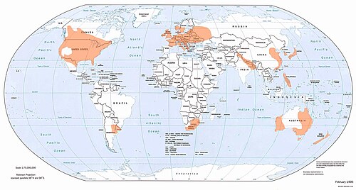
In dynamic meteorology, tornado season is not defined by strict calendar dates, but rather by the shifting of global wind patterns and thermal gradients. The phenomenon is most famously associated with the central and southern regions of the United States—an area colloquially known as Tornado Alley—though similar seasonal peaks occur in other mid-latitude regions around the world, including the Pampas of South America, parts of Europe, and the Bengal Basin.[1]The term Tornado Alley was coined in 1952 by United States Air Force meteorologists Robert Miller and Ernest Fawbush during a research project studying severe weather in the central states.
The primary driver of this period is the seasonal transition of solar radiation, which warms the lower atmosphere while the upper atmosphere retains colder air masses. This steep lapse rate creates profound atmospheric instability, providing the buoyant energy necessary for explosive thunderstorm development.
2. Atmospheric Dynamics and Ingredients
The onset of the peak instability period relies on the simultaneous presence of four foundational atmospheric ingredients:
- Low-Level Moisture: Abundant, warm, humid air transported from tropical maritime regions, such as the Gulf of Mexico, serving as the primary fuel source for convective updrafts.
- Atmospheric Instability: A rapidly cooling atmosphere with height (steep lapse rates), allowing parcels of warm air to rise unchecked once initiated.
- Vertical Wind Shear: Significant changes in wind speed and direction with altitude. Strong shear imparts environmental helicity, encouraging the rotating updrafts (mesocyclones) characteristic of supercell thunderstorms.
- Lifting Mechanism: A physical force to trigger the updraft, typically provided by cold fronts, drylines, or warm fronts intersecting the moist air mass.
During the peak season, the polar jet stream migrates northward, placing its strong upper-level winds directly above warm, moist surface air masses. This overlap maximizes both lift and wind shear, significantly increasing the probability of tornadogenesis.
3. Spatial and Temporal Shifts
Tornado season exhibits a distinct geographical progression over the course of the year, driven by the seasonal migration of the thermal equator and the polar jet stream.
- Early Spring (March – April)
The primary risk zone begins in the Gulf Coast region and the Deep South (often referred to as Dixie Alley).[2]https://www.spc.noaa.gov/faq/tornado — The term Dixie Alley was introduced in 1971 by National Severe Storms Forecast Center director Allen Pearson to describe the region's distinct tornadic geography. Early in the year, the polar jet stream remains south, bringing powerful upper-level disturbances into contact with early warm air surges from the Gulf of Mexico. Tornadoes during this phase are often fast-moving, embedded in squall lines, and frequently occur at night.
- Late Spring (May – June)
This period represents the absolute climatological peak of atmospheric instability for the central United States. As the continent warms further, the region of maximum convective available potential energy (CAPE) shifts into the Great Plains, covering states such as Texas, Oklahoma, Kansas, and Nebraska. Mid-to-late spring typically sees the highest concentration of intense, long-track supercell tornadoes due to the ideal balance of extreme instability and strong synoptic wind shear.
- Summer (July – August)
As the jet stream retreats into southern Canada, the primary corridor of instability shifts northward into the Northern Plains and the Upper Midwest. While overall wind shear decreases during the summer months—leading to a reduction in the average intensity of tornadoes—surface heating and high localized moisture can still produce frequent severe weather outbreaks.
- Secondary Autumn Peak (October – November)
A secondary, smaller surge in atmospheric instability often occurs during the late autumn. As the hemisphere begins to cool, cold air masses push southward once again, re-engaging the warm waters of tropical regions. This creates a secondary maximum in tornado activity, predominantly affecting the lower Mississippi Valley and Southern states.
4. Regional Variations Outside North America
While North America experiences the most severe and frequent tornado seasons, similar atmospheric instability periods occur globally:
- South America (Gran Chaco and Pampas): The region spanning central Argentina, Uruguay, and southern Brazil experiences its peak instability period from November through April, fed by warm air from the Amazon Basin meeting cold Andean and Antarctic winds.
- South Asia (Bangladesh and East India): The transition period prior to the summer monsoon (March through May) features extreme atmospheric instability, generating some of the deadliest tornadoes in recorded history due to high population density and severe environmental energy.[3]The Daulatpur–Saturia tornado in Bangladesh on April 26, 1989, killed an estimated 1,300 people, making it the single deadliest tornado in recorded history.
- Europe: The European tornado peak generally occurs in mid-to-late summer (June through August), driven by localized thermal breezes and surface heating, though winter tornadoes occasionally strike Western Europe along strong cold fronts.
5. Impacts on Prediction and Preparedness
The predictability of the peak atmospheric instability period allows meteorological agencies to issue long-range seasonal outlooks and heightened daily warnings. Modern weather forecasting utilizes high-resolution computer modeling, thermodynamic soundings, and Doppler radar networks to monitor severe weather parameters continuously throughout the season.
Public safety infrastructure, regional building codes, and community emergency management strategies rely heavily on the climatological data of tornado seasons to mitigate risk, optimize resource allocation, and enhance public awareness before the onset of peak annual activity.
6. Trivia
6.1 Seasonal Asymmetry and Hemispheric Latitudinal Shift
The atmospheric instability window known as "tornado season" does not occur simultaneously across the globe, nor does it follow a static geographic boundary. In the Northern Hemisphere, the peak period migrates northward from late winter through mid-summer. Early in the year (February to March), the primary zone of cyclogenesis resides over the Gulf Coast of the United States (the Deep South), driven by the intrusion of cold continental polar air masses into warm, moist maritime tropical environments. As solar irradiance increases the ground temperature of the North American interior, the jet stream retreats northward, shifting the primary region of severe convection to the Great Plains ("Tornado Alley") in May and June, and subsequently into the Canadian Prairies by July. Conversely, the Southern Hemisphere experiences its primary convective peaks between November and April, heavily localized in the *Pampas* region of South America and southeastern Australia.
6.2 Dual-Peak Annual Distribution Pattern
While spring represents the primary maximum for tornadic activity in North America due to extreme thermodynamic instability and strong vertical wind shear, a distinct secondary peak—frequently termed the "Autumnal Mini-Season"—occurs between October and November. This phenomenon is driven by the southward re-advancement of the polar jet stream intersecting with residual late-summer thermal energy over the southern United States. Unlike the spring season, which is dominated by daytime surface heating (diurnal forcing), the autumn peak relies heavily on high-shear, low-CAPE (Convective Available Potential Energy) environments, often resulting in fast-moving, nocturnal linear mesoscale convective systems (MCS) and quasi-linear convective systems (QLCS).
6.3 Nocturnal Convection Risk Variance in the Dixie Alley
The region known as Dixie Alley (encompassing parts of Mississippi, Alabama, Tennessee, and Georgia) exhibits a spatial-temporal divergence from the traditional Great Plains tornado season. In this region, tornado season peaks earlier (March through April) and possesses a disproportionately high frequency of nocturnal tornadoes. Nighttime tornadogenesis in this corridor is facilitated by strong low-level jets (LLJ) that intensify after sunset, transporting warm, moist air into the region despite the absence of solar heating. Statistical mortality rates are significantly higher during the Dixie Alley peak compared to the Great Plains peak, primarily due to the visual obscurity of nocturnal funnels, high forest canopy coverage, and elevated population density.[4]https://www.spc.noaa.gov/wcm/torngraph-big.png — Studies showed that nighttime tornadoes in this region were more than twice as likely to result in fatalities compared to daytime events.
6.4 Teleconnection Modulation Factors (ENSO and PDO)
The intensity, spatial distribution, and temporal onset of tornado season are heavily modulated by global climate teleconnections, most notably the El Niño-Southern Oscillation (ENSO) and the Pacific Decadal Oscillation (PDO).
- La Niña Phase: Tends to produce a highly active and early-onset spring tornado season in the United States. The northward displacement of the polar jet stream over the Pacific allows a more frequent moisture transport mechanism from the Gulf of Mexico, aligning cold, upper-level troughing over the central U.S.
- El Niño Phase: Generally suppresses central Plains tornado activity due to a southern-branch jet stream that shifts the storm track over the Gulf of Mexico, trapping stability-inducing cool air over the southern states and limiting deep atmospheric moisture transport northward.
6.5 Troposphere-Driven Orographic Amplification Mechanisms
The unique intensity of the North American tornado season is uniquely dependent on the specific macro-orography of the continent. The longitudinal alignment of the Rocky Mountains plays a crucial role in dynamic mid-level cooling: as westerly winds traverse the high terrain, they form a dry, stable layer elevated above the warm, moist air flowing from the Gulf of Mexico. This process creates an "elevated mixed layer" (EML) characterized by a strong thermal inversion (a "cap"). The cap prevents premature, weak convection, allowing potent thermodynamic potential (high CAPE) to accumulate throughout the day. When synoptic scale lifting mechanism breaks the cap in late afternoon, explosive, violent tornadogenesis (EF4 to EF5 intensity) typically occurs.
6.6 Tropical Cyclone-Induced Secondary Cyclogenesis
The tail end of the Atlantic hurricane season (August through October) introduces a distinct sub-category of tornado season driven by landfalling tropical cyclones.[5]https://www.nhc.noaa.gov/climo — Hurricane Ivan in 2004 spawned a record 120 tornadoes across nine states over a three-day period after making landfall. As a tropical storm or hurricane moves inland, the dramatic increase in surface friction rapidly decelerates surface winds while upper-level winds maintain speed. This process generates extreme low-level vertical wind shear within the right-forward quadrant of the cyclone. These tornadoes, while typically weaker (EF0 to EF2) and shorter-lived than classic supercell tornadoes, can spawn in rapid bursts—often producing dozens of tornadic funnels within a 24-to-48-hour period independently of classic cold-front dynamics.
Child documents of "Tornado season"
None yet.